
Travel Guide: The Silk Road // Pakistan to China: Part 2
- Sep 18, 2025
- 8 min read
Part II - Chilas to Hunza, Northern Areas, Pakistan
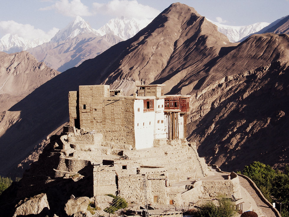
Baltit Fort, Karimabad, Hunza
Day three | 6 September | Chilas to Gilgit, Gilgit to Hunza
After bumping into a tour group yesterday, our appetites were whet to see the famous petroglyphs of Chilas. Centuries of travel through this area from the 1st century BC saw merchants, monks and warriors stopping along their route to scratch drawings and inscriptions into the rocks.
In the 3 sites we saw around Chilas there were no inscriptions, only a strong buddhist influence; stupas, sitting buddhas and the recorded stories of belligerent tribes who came into conflict with the buddhists; warriors, men on horseback, fallen stupas, sun symbols. And then lots of large horned ibex, considered a trophy, then as now. The rocks containing them were large, twisted formations scattered along the Indus River, with nooks and crannies to climb into. The petroglyphs were in amazing condition, some very bright. People had scratched out the faces of the buddhas, another had painted his election slogan over a large stupa petroglyph.


After having our fill of petroglyphs for two and a half hours, we caught a mini bus on the Karakoram Highway (KKH) without too much trouble to Gilgit, about 3 hours away. 150 PKR each and we had the back row to ourselves.

The view, or what I could see of it, was dramatic but very barren and desolate. The KKH, following closely the silty Indus below, wound through completely dry and empty rocky mountains towering on both sides. At one point on road we turned a bend, and someone told us that this is where three of the world's largest mountain ranges met: the Hindu Kush, the Himalaya and the Karakoram. Astounding, it blows the mind! These three giants spanning all Central and South Asia converging in one place. And what a magical place it is!


On the Karakoram Range:
The Karakoram is home to the highest concentration of peaks over 8000m in height to be found anywhere on earth, including K2, the second highest peak in the world at 8,611 m. The range is about 500 km in length, and is the most heavily glaciated part of the world outside the polar regions. The Siachen Glacier at 76 kilometers and the Biafo Glacier at 63 kilometers rank as the world's second and third longest glaciers outside the polar regions.
The Karakoram is bounded on the northeast by the edge of the Tibetan Plateau, and on the north by the Pamir Mountains. The southern boundary of the Karakoram is formed, west to east, by the Gilgit, Indus, and Shyok Rivers, which separate the range from the northwestern end of the Himalaya range proper as these rivers converge southwestward towards the plains of Pakistan.
Karakoram is a Turkic term meaning black gravel. The name was first applied by local traders to the Karakoram Pass. Early European travelers, including William Moorcroft and George Hayward, started using the term for the range of mountains west of the pass, although they also used the term Muztagh (meaning, "Ice Mountain") for the range now known as Karakoram. Later terminology was influenced by the Survey of India, whose surveyor Thomas Montgomerie in the 1850s gave the labels K1 to K6 (K for Karakoram) to six high mountains visible from his station at Mount Haramukh in Kashmir.
Due to its altitude and ruggedness, the Karakoram is much less inhabited than parts of the Himalayas further east. European explorers first visited early in the 19th century, followed by British surveyors starting in 1856.
The Muztagh Pass was crossed in 1887 by the expedition of Colonel Francis Younghusband and the valleys above the Hunza River were explored by General Sir George K. Cockerill in 1892. Explorations in the 1910s and 1920s established most of the geography of the region. The Karakoram is in one of the world's most geologically active areas, at the boundary between two colliding continents.
A significant part, 28-50% of the Karakoram Range is glaciated, compared to the Himalaya (8-12%) and Alps (2.2%). Mountain glaciers may serve as an indicator of climate change, advancing and receding with long-term changes in temperature and precipitation. Karakoram glaciers are mostly stagnating or enlarging, because, unlike in the Himalayas, many Karakoram glaciers are covered in a layer of rubble which insulates the ice from the warmth of the sun. Where there is no such insulation, the rate of retreat is high.
Source: https://en.wikipedia.org/wiki/Karakoram

Villages in Hunza are perched mid-way up steep mountain sides. Below, the deep valley of the Indus River. Above, the lofty peaks of the Karakoram range.
The quality of the road was average, allowing a reasonable speed with the occasional need to slow down for potholes. The bus was filled with locals and blared Indian music. The scene repeated itself until we reach Jalalabad, just south of Gilgit. Rising above the Indus on a well irrigated and lush green plateau, it was an unexpected vista.
The whole of this area, all up the valley, is supported by an impressive system of hundreds of kilometers of water channels, used mostly for irrigation but also for hydropower. Bringing the water from sources many kilometers away, dug into cliffs high above the villages, they allow the people of the area to grow a range of cereals, fruits and vegetables; apples and seed fruits are among the most popular. Another feature of the area are massive messages written high up on the mountains with white stones; mostly congratulating the Aga Khan on his golden jubilee or welcoming this or that Imam to the region. From Gilgit, the area is predominantly Shia, with Ismailis forming the majority of Hunza and some other areas.
We reached the bus stand at Gilgit, 10km from Gilgit proper, after filling foreigner registration forms twice. Given our tight timeline for this part of the trip, we decided to skip a visit to Gilgit and keep heading up the valley. We had a 20 minute wait, during which we bought some mecca cola and pomegranates before being packed into a "flying coach" for our trip to Hunza; specifically Karimibad village.
About 2 hours drive with a chai break in the middle, the scenery became more impressive as we moved along. More, small and lushly green villages with stone and cement houses, farmland, poplars and fruit trees strung out along the highway and Indus. The old route, connecting Hunza with China and the South before the KKH was opened to the public in 1982, perched on the other side of the river, higher up the mountains. Before reaching Aliabad (the capital of Hunza), we stopped for a chai and a chop shuro - a kind of cornish pasty local to the area and filled with onions. Further along the Indus, we started catching sight of the breathtaking Rakaposhi (7788m) towering above with its head in the clouds and draped in snow.


Ismaili Islam
An 8th century split among Shiites, who disagreed on which son of the 6th Imam should succeed him, gave rise to the Ismaili branch of Islam. For Ismaili Shiites, the line of Imams continues into the present. Ismailis today number several million and live in pockets of Pakistan (Hunza and Gojal), Afghanistan and Central Asia, India, East Africa, Iran and Syria and their present Imam (since 1957), Prince Karim Aga Khan, is no. 49 in the line of Imams.
All in all, it was a subtle, but definite difference felt in Karimabad and Passu. I wouldn’t know how much to ascribe to the difference in religious practices, but the women seem more free and active in social and economic activities and there seems to be a huge feeling of community cooperation, as witnessed by the high quality and upkeep of public infrastructure we could see, like the roads, canals, schools and pathways.
Day 4 | 7 September | Karimabad and Ganesh
Karimabad is spectacular. Perched mid way up the mountain side below Ultar Peak (7388m) and Glacier, above the village of Ganesh, and across the Hunza Valley from Nagyr, it is a fairy tale village of quiet paths, rich gardens, bubbling water channels and the magnificent Baltit Fort and surrounding houses. Watched over by Rakaposhi (7788m) and Diran (7270m) mountains, it is as beautiful as it is peaceful.
We rose early to make a large circuit of the village, following water channels from the higehest point. It took us around 2 hours to circuit the village, arriving back in the centre of the village for breakfast, which invariably involves apricots in one form or another!
Baltit Fort - one of the most incredibly situated and beautifully constructed buildings I've ever seen - has been well restored. The Aga Khan Rural Support Programme (AKRSP) is very active here in restoring and maintaining cultural and economic infrastructure. The water channels are a work of art; they run alongside the neat sand foot paths, controlled by a system of locks and watering the whole village. They are fed from below Ultar Peak and flow in front of the sweet stone and wood houses. People float milk and butter in small bags inside the water to keep them cool and have built little wooden bridges crossing the channels from their homes to the pedestrian paths that wind around the village. The gardens are meticulous and a wide variety of of fruit and vegetables are grown. Aside from the seed fruit there are apples, melons, pumpkins and herbs.
People are polite, if not overly friendly as elsewhere I've been in the country. The women walk easily in the streets, some covered in scarves over a pill-box hat, some uncovered, and they talk to men freely (which, if you've spent time in other rural areas in Pakistan, you will know to be quite rare). It seems that not so long ago the area was much more barren and a limited number of crops were grown. AKRSP and, much more significantly, the KKH, has done a lot to change this.
Later in the morning we walked down to Ganesh village, where we met Mumtaz, a friend we made on the bus yesterday. His father is involved in the restoration of the original Ganesh village and site of the first Hunza settlement.
It is a collection of still-lived in houses, 14 watchtowers - manned by the original 14 families of Hunza - and four 100-200 year old mosques that act as personal sites for the worship of the more influential families. It was spectacular. A water reservoir at the entrance to the village was used by Hunza warriors to train in adapting to the cold water before crossing the Indus river to fight their enemies in Nagyr village. There has supposedly been a settlement here for around 1100 years, and Ganesh village is supposedly 800 years old. Before the KKH was finished in 1968, there was little contact with the outside world. The first car arrived here only after the KKH was complete.
We sat with Mumtaz’s father sipping tea and eating chips for an hour as we fired questions at him about the history and current situation of Hunza. In the afternoon we visited the spectacular Baltit Fort and old Hunza village. The photos will speak for themselves!


A tale of siblings and rivalries - Lonely Planet
The origins of the separate Hunza and Nagyr Kingdoms are obscured by legend. However, they probably arose from a marriage of royal cousins in the 15th century that produced twin sons, Maglot and Girkis, later to become the rulers, respectively, of Nagyr and Hunza. From infancy, so the story goes, they had a mutual hatred and as kings they led their people into frequent battle. Over the centuries their royal descendants have continued the feud. The valley's modest agricultural output has for years been supplemented by raids on caravans traveling between Kashgar and Kashmir, and by slave trading. Yaqub Beg, who proclaimed an independent Turkestan Republic in Xinjiang in the 1860s, put a temporary end to the raids. This economic blow led Hunza and Nagyr to declare allegiance to the British-alligned Maharaja of Kashmir. In 1886, Safdar Ali became Mir of Hunza. Within two years he resumed the caravan raids and played host at Baltit fort to a party of Russian “explorers”. Britain decided to improve supply lines from Kashmir and reopen its agency at Gilgit. Within 5 years a British-Kashmiri force had occupied the valley and installed its own Mir, Nazim Khan. In Hunza, Nazim Khan (died 1938) was succeeded by his son, Ghazan Khan (died 1945). Within weeks of partition, an uprising in Gilgit against the Maharaja of Kashmir brought Hunza and Nagyr into Pakistan. They remained semi-autonomous until 1974 when they were merged with Pakistan, reducing their rulers to district officials.


What an incredible travel story and adventure along the Silk Road. The landscapes and cultural experiences sound unforgettable. Reading about journeys like this gives me the same mix of excitement and focus I feel while trying to survive difficult stages in space waves.